Map work: how to read a map
A map is a picture of a place seen from above, like a bird would see it. Learn the secret code every map uses, then make a map of your own.
The five things every good map has
- A title: what place the map shows.
- A north arrow: which way is north. On most maps, north is at the top.
- A scale: how real distances shrink on paper. On a scale of 1:50,000, one centimetre on the map is 50,000 centimetres (half a kilometre) on the ground.
- A legend (or key): what the symbols and colours mean. Blue for water, green for parks or forest, black lines for roads, and so on.
- A grid: lines that help you say exactly where something is, like “square C4”.
Hills on a flat page: contour lines
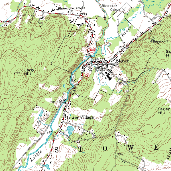
How can a flat map show hills and coulees? With contour lines. Each brown line joins places that are the same height above sea level.
Try it: make a hill out of play dough. Slice it into flat layers with dental floss, all the same thickness. Trace around each layer, one inside the other, on paper. You’ve just drawn a contour map!
Where on Earth? Latitude and longitude
Map-makers wrap the whole Earth in an invisible grid. Latitude lines run east and west, and tell you how far north or south of the equator you are. Longitude lines run from pole to pole, and tell you how far east or west you are.
Lethbridge is at about 49.7° north and 112.8° west. That’s just a little north of the 49th parallel, the line that makes most of the border between Canada and the United States.
✏ Try it yourself
- Map your bedroom. Draw it from above, as if you were a fly on the ceiling. Add a north arrow (ask an adult which way north is, or use a compass), a legend for your bed, desk and door, and a title.
- Treasure map. Hide a small treat in the yard, then draw a map with a scale (“1 square = 2 big steps”) for a friend to find it.
- Find your house on a real map. Natural Resources Canada’s free Toporama shows Canada’s topographic maps. Can you find the coulees? Look for the tight contour lines!
The hidden dots that hold the map together
Every map of Alberta is measured from survey markers: brass discs and iron pins you can find in sidewalks and ditches. Learn to spot them in Survey markers.
Maps and weather
Weather forecasters use special maps too. Learn to read them in Weather School: Draw your own weather map.
❓ Quick quiz
Guess first, then tap to see the answer.
What does a map’s legend tell you?
What the symbols and colours on the map mean.
Contour lines are very close together. Is the ground steep or flat?
Steep! Close lines mean the height changes quickly, like a coulee wall.
On a 1:50,000 map, how far is 2 cm on the ground?
1 kilometre. Each centimetre is 50,000 cm, which is half a kilometre.
Which lines tell you how far north of the equator you are?
Lines of latitude.
🏫 For teachers and parents
- Ages: 6 to 12. The bedroom map suits younger kids; scale, contours and latitude suit grades 4 to 7.
- Curriculum links: mapping skills in social studies, measurement and ratio in math.
- Class activity: each group maps one part of the school yard to the same scale, then join the maps together into one big map.
- Play-dough contour map: about 30 minutes, and it works every time.
- More ideas in the Teachers’ Corner.
More Earth Explorers
Sources: Natural Resources Canada, Toporama and the Atlas of Canada.